Bolungarvík, Westfjords · 638 m · road open mid-June to mid-September
Bolafjall: the viewing platform above Bolungarvík — road, season and how to visit
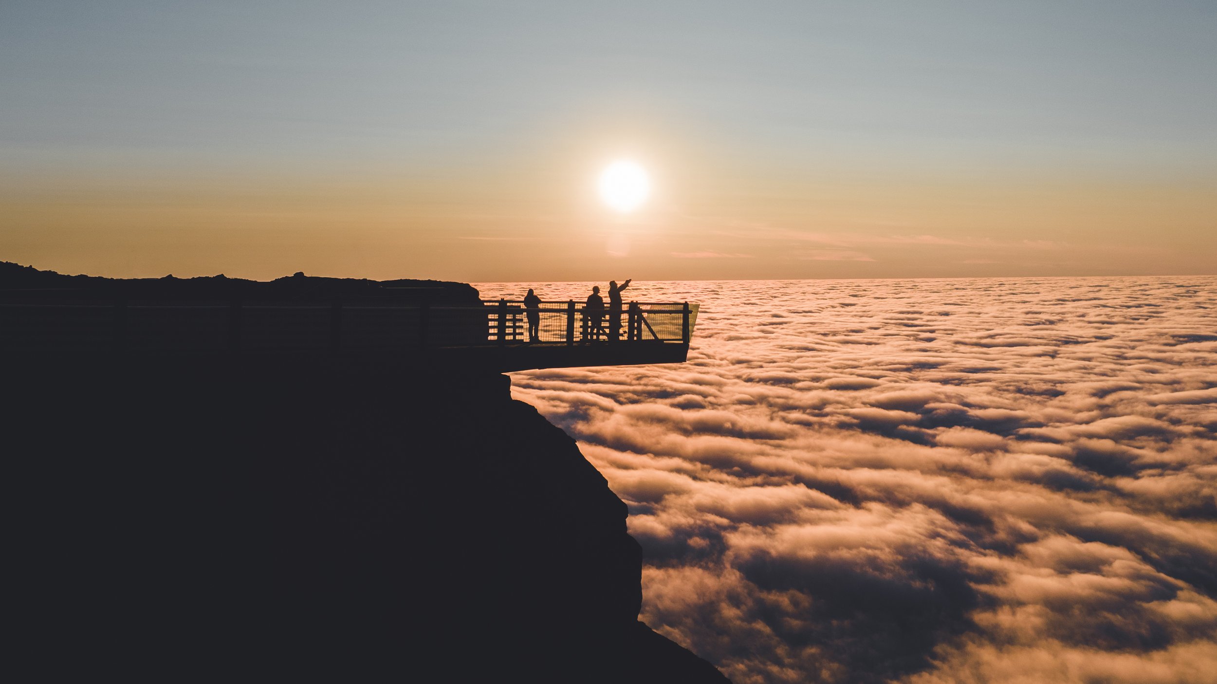
Bolafjall is the 638-metre mountain standing directly above Bolungarvík in the Westfjords. Since 2022 a 60-metre viewing platform has reached out from its cliff edge, about 600 metres above the sea, looking out over Ísafjarðardjúp towards Jökulfirðir and Hornstrandir. By car you take a steep gravel road from Bolungarvík — about 10 km — usually open from mid-June to mid-September; on foot you can go up any time of year, snow included, which is how many locals do it. Dúfan Apartments is in Bolungarvík, at the foot of the mountain.
Bolafjall at a glance
Height
638 m — the platform sits about 600 m above the sea
The platform
60 m long, built down into the cliff; opened 2022
The road
About 9.8 km of gravel from Bolungarvík; steep, narrow, few guard rails
Road open to cars
Typically mid-June to mid-September, weather and road permitting
On foot
Year-round, snow included — a loop of about 11 km with roughly 470 m of climbing
From Ísafjörður
15 minutes to Bolungarvík through the tunnel, then the mountain road
From Dúfan
Allow 20–25 minutes each way — short distance, slow road
The platform: Framúrskarandi Bolafjall
The platform has an official name — Framúrskarandi Bolafjall, “Outstanding Bolafjall”, a pun in Icelandic, since framúrskarandi also means “jutting out”. It came out of a 2019 design competition won by the architects Sei and Argos with the landscape architects Landmótun, and the engineering firm EFLA did the structural, wind and geotechnical design. It is 60 metres long and steps down into the cliff, so you walk out and slightly down until the mountain falls away beneath you. It was formally opened on 1 September 2022 by Pétur Vigfússon, a resident of Bolungarvík.
The road up
From Bolungarvík you take road 630 towards Skálavík, then turn up the mountain on the road built to serve the radar station at the top. It is about 9.8 km from town to the summit, on gravel the whole way. Guide to Iceland puts the average gradient at almost 7 per cent, with stretches of 12 per cent, and describes the road as narrow, steep and curvy with few guard rails. Practical advice before you go:
- Check road.is the same day — the road is only open in summer, and closes even then when conditions turn.
- Guides recommend a 4x4 and an experienced driver. Check your rental agreement before driving any mountain road; terms differ between companies.
- Look up at the mountain from town first. If the summit is in cloud, the view is too — wait for it to lift.
- Take a warm layer. The platform is about 600 metres up and fully exposed to the wind off the sea.
Walking up — any time of year
You do not need the road to be open. Bolafjall can be walked, and locals go up on foot all year, snow included — it is the only way to the top outside the summer road season. A popular route on komoot, the Bolafjall skywalk loop from Hlíðardalur above Bolungarvík, is about 11.3 km with roughly 470 metres of climbing, rated moderate, and takes around three and a half hours. When the road is closed to cars you can also walk the gravel road itself; one hiker on komoot walked the last 3.5 km of it that way, into very strong wind. Before you set off:
- Check the forecast on vedur.is. In winter, also read the avalanche forecast for the northern Westfjords — the Icelandic Met Office publishes one, and conditions on a 600 m mountain are not the conditions in town.
- In snow, go with proper boots, traction spikes or crampons, and real winter layers. Daylight is short in the Westfjords winter, so start early and turn back with light to spare.
- Leave a travel plan on safetravel.is, or at least tell someone at home your route and when you expect to be back.
- The summit is often in cloud and the wind up there can be strong when the town is calm. A clear, settled day is worth waiting for.
What you see
The platform looks out over Ísafjarðardjúp, the great fjord that splits the northern Westfjords, and across to Jökulfirðir and the cliffs of Hornstrandir, the uninhabited nature reserve at the northern tip of the region. Below you is open sea and the coast running out towards Skálavík. The Westfjords Way puts it simply: the view reaches over Ísafjarðardjúp and Jökulfirðir, “and some people say all the way to Greenland.” We will leave that one to your luck with the weather.
The radar station on the summit
The domes on top of Bolafjall are a working radar station, one of the four sites of the Iceland Air Defence System, run today by the Icelandic Coast Guard. The road exists because of it. It is an active installation, so keep to the marked paths and the platform rather than wandering the summit.
Combine it with Skálavík
Bolafjall and Skálavík share the same road. Road 630 carries on past the turn to the mountain to Skálavík, an abandoned settlement in the next bay with a black-sand beach and a river running to the sea — about 10.8 km from Bolungarvík in all. The regional tourist board suggests exactly what we would: the platform first, then a coffee and a slow walk along the beach. Allow half a day for both and you will not feel rushed.
When to go
By car, only while the road is open — typically mid-June to mid-September. On foot, any time of year in settled weather. Either way, pick a clear day: the summit is often in cloud when the town below is not. In June and July the light lasts almost all night, so late evening is as good as midday and far quieter. A winter walk in snow is a different and beautiful mountain, but plan it as a winter mountain walk, not a stroll. The Northern Lights are not a realistic plan from the platform by car: the sky only grows dark again near the end of the road season, and that is a steep gravel road to drive at night.
Where to stay near Bolafjall
The road up Bolafjall starts in Bolungarvík, and Dúfan Apartments is in the middle of the town — four self-catering apartments, 24-hour self check-in, full kitchens and free parking. That means you can watch the summit from the window and drive up the moment the cloud lifts, rather than committing to it from Ísafjörður. Booking direct is always our lowest price.
Common questions
How high is Bolafjall?
Bolafjall is 638 metres high. The viewing platform sits about 600 metres above the sea, on the cliff edge just below the summit.
When is the road to Bolafjall open?
Typically from mid-June until mid-September, and only when weather and road conditions allow — it can close in season too. Check road.is on the day you plan to go. Outside that window the road is closed and the platform cannot be reached by car.
Do you need a 4x4 to drive up Bolafjall?
Guides recommend a 4x4 and an experienced driver. The road is about 9.8 km of gravel from Bolungarvík, averaging almost 7 per cent with stretches of 12 per cent, narrow and with few guard rails. Check your rental agreement before driving it, as terms for mountain roads vary between companies.
How far is Bolafjall from Ísafjörður?
Ísafjörður to Bolungarvík is about 15 minutes through the Bolungarvíkurgöng tunnel. From Bolungarvík the mountain road is about 9.8 km to the top; allow 20–25 minutes each way, as it is a slow road.
What can you see from Bolafjall?
Ísafjarðardjúp, Jökulfirðir and the cliffs of Hornstrandir, with open sea below. On the clearest days, according to the Westfjords Way, some people say the view reaches all the way to Greenland.
When was the Bolafjall viewing platform built?
It opened in 2022 and was formally inaugurated on 1 September 2022. It came out of a 2019 design competition won by Sei, Argos and Landmótun, with engineering by EFLA. Its official name is Framúrskarandi Bolafjall.
Can you hike up Bolafjall?
Yes. A popular route, the Bolafjall skywalk loop from Hlíðardalur above Bolungarvík, is about 11.3 km with roughly 470 metres of climbing, rated moderate, and takes around three and a half hours. When the road is closed to cars you can also walk up the gravel road.
Can you visit Bolafjall in winter?
Yes, on foot — locals walk up all year, snow included. The road is closed to cars outside mid-June to mid-September, so winter is a walking trip only. Treat it as a winter mountain walk: check the weather and the avalanche forecast for the northern Westfjords on vedur.is, take spikes or crampons and warm layers, start early for the short daylight, and leave a travel plan on safetravel.is.
Where is the closest accommodation to Bolafjall?
Bolungarvík, the town at the foot of the mountain. Dúfan Apartments has four self-catering apartments there, 20–25 minutes from the platform by car and 15 minutes from Ísafjörður.
More around Bolungarvík: things to do near Bolungarvík → · where to stay in the Westfjords → · Westfjords events and festivals →
Sources: Wikipedia, EFLA, westfjords.is, Westfjords Way, Guide to Iceland, komoot, road.is, vedur.is, safetravel.is.
Wake up below Bolafjall
Four self-catering apartments in Bolungarvík, at the start of the road up the mountain — live prices, and direct is always our lowest.
Book direct securely — availability and payment are handled by our booking system, and your confirmation arrives by email.